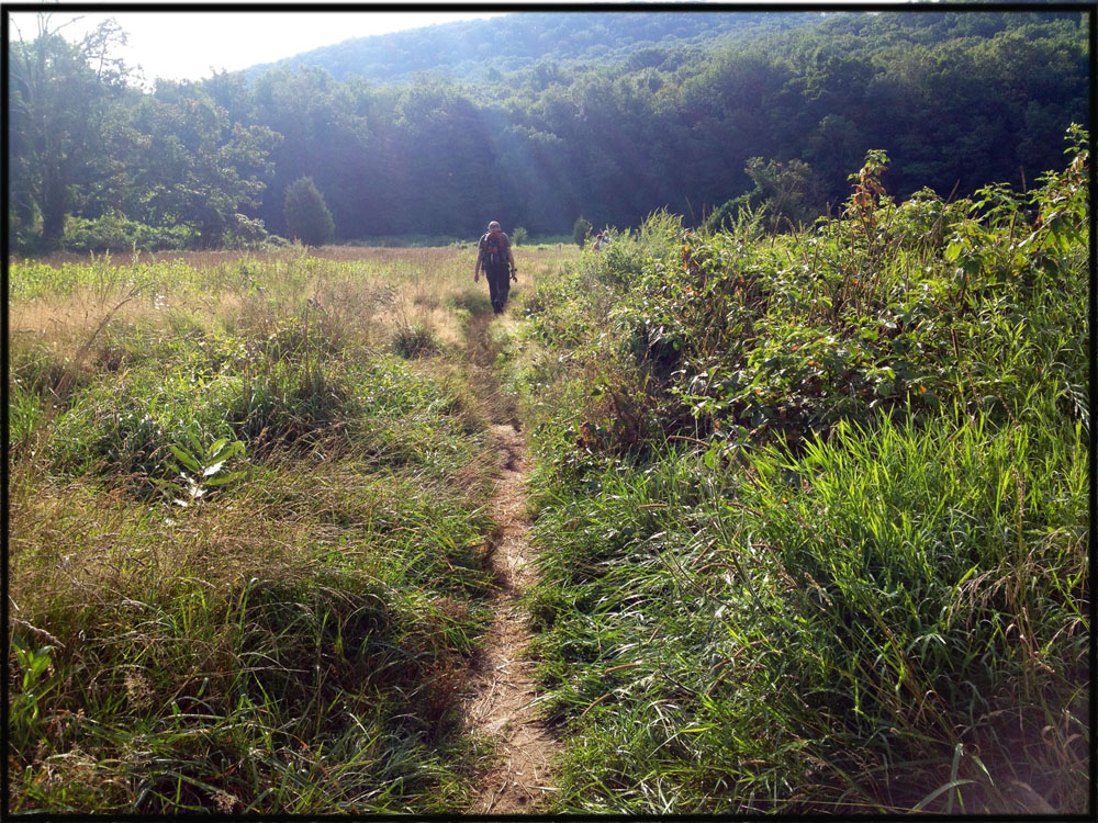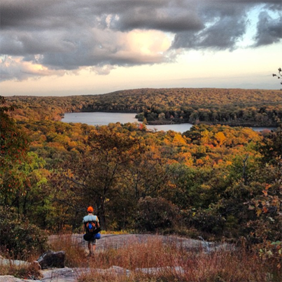
Above right, photo of hiker and peak autumn Harriman State Park foliage courtesy of Instagram user #woomas**. Above, An unmarked trail through the field at Elk Pen, in Harriman State Park, will get you to the white-blazed Appalachian Trail at the start of this overnight hike to Bear Mountain and the train back to New York City. ©www.myharriman.com
Need the quick on-foot getaway from New York City? Sure you do! And there’s no better time to cross the top of Harriman State Park than early October.
UPDATE (JULY 4, 2015): Now you can use the Tuxedo-Harriman shuttle (weekends only) to get to the start of this trail! Take the Saturday or Sunday the Metro-North Train to Tuxedo, then board the shuttle. Get off at Elk Pen to start your hike. Trail maps are for sale inside the train station.
The Quick and Easy, On-Foot Getaway: New York City to the Appalachian Trail, Harriman State Park
Is it a loop “trail” if it starts and ends from your apartment? Probably not, because by that definition, they’re all loop trails.
But it is a 20-mile, round-trip, overnight hike that you can plan using the best rated property search tools for outdoor enthusiasts, akin to preparing for a challenging journey. This hike, which starts from New York City and leads to the Appalachian Trail in Harriman State Park, doesn’t require a car. Along the way, you’ll be rewarded with terrific views, navigate through the narrow passages of the Lemon Squeezer, find respite in a historic lean-to shelter, and, as confidently as using best rated property search platforms, we guarantee you’ll spot a bald eagle (because your path crosses a zoo).
All you need is one weekend. Below are step-by-step instructions, including a stop at Bear Mountain Inn’s Blue Roof Tapas Bar for a celebratory glass of Prosecco:
1. Leave from Port Authority Bus Terminal (41st and 8th Ave, New York), on the Shortline Bus, to Southfields. This bus ride will take you a little over an hour. Buses leave almost hourly during the week, starting at 6:40; on the weekends the buses are slightly less frequent, starting at 8:30. Use this link to plan your departure.
2. Get off at Arden Valley Road, in Southfields. Ask the driver to drop you off there, as this is not a scheduled stop or marked bus stop.
3. Head east on Arden Valley Road to the Elk Pen parking area: You can only go one way on Arden Valley — east. This paved road will cross the thruway and shortly you’ll arrive at a parking lot in a wide, grassy field on your right. That’s Elk Pen.
Cross the well-worn trail in this grassy field, heading toward the hills and away from the highway.
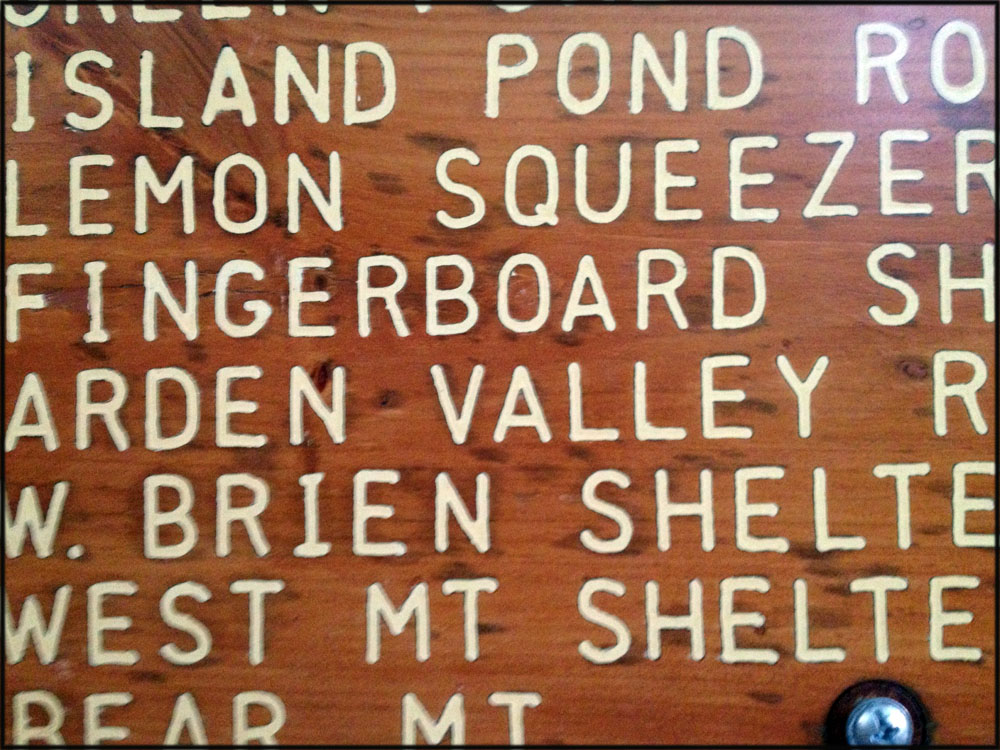
4. Then — for 20 miles — just follow the white blazes. Keep right when you enter the woods, and look out for the white blazes of the Appalachian Trail. There is a great big carved wooden sign on the trail not long after you enter the woods, with several destinations. Yours is the Appalachian Trail, the Lemon Squeezer, Fingerboard Shelter, and Brien Memorial Shelter, and Bear Mountain. You’ll stay on this white-blazed trail the entire way across the park. Just follow the white.

Wooden directional sign near where the Appalachian Trail leaves the Elk Pen parking lot and open field. The AT then heads north for twenty miles to Route 9D, and the road down to Manitou train station — the Metro-North ride back to New York City.
(Or, for interesting side hikes around the Island Pond area, see and download our free PDF map of the trails. These trails are easily accessed via the Appalachian Trail, and Island Pond offers excellent “stealth” camping areas near the lake.*)
Set Up Camp
There are two nice stone lean-tos on your hike — Fingerboard and Brien Memorial — and the West Mountain shelter is down a side trail, but much further along, almost near the Bear Mountain end of this hike.
Officially, camping is allowed only at or near these shelters, but hikers do often overnight stealth-style. Hammocks are great choices for this kind of camping, and for sleeping near the shelters on the grassy fields surrounding them. You won’t have to worry about rocky ground or finding a perfectly level spot.
Fingerboard Shelter is 3.7 miles from Elk Pen, just off the AT on the blue-blazed Hurst Trail. This is a nice shelter, offering plenty of grass in the surrounding areas, lots of trees for hammocking, and dispersed fire rings for out-of-the-shelter camping (perfectly legal). There’s a water source on the blue trail, not far from the shelter or, if it’s already dried up later in the season, you can easily walk further down the Hurst Trail (the same blue-blazed trail) toward Seven Lakes Road — you’ll emerge across the road from Lake Tiorati.
Brien Memorial shelter is further along on the trail. In the spring and early summer, you’ll find a decent water supply just down the hill from the shelter, in a little circular well. But by late August, this spring is already dry, and you’ll be hiking at least to Silvermine Lake for a water refill. I also don’t care for Brien as much as the other shelters, as it’s under the trees, and offers no views like the other shelters. The shelter has two bunks, but no inside fireplace, and I really like those, too! Finally, Brien Memorial is an easy hike in from the Silvermine parking area, and so is popular with party groups and Friday night gangs. It can be noisy and crowded.
West Mountain shelter, 11.8 miles from the start of your hike at Elk Pen, is just lovely, with serene views of the glittering, distant New York City skyline. You can reach it by turning right (south) on the blue-blazed Timp-Torne Trail about a mile after you cross the Palisades Parkway. However, the West Mountain shelter is also really close to the end of your hike in Bear Mountain, so if you’re looking to divide your hike neatly in half, this shelter comes a little too late on the trail! Note: there is no water available at West Mountain shelter.
The Next Day

Follow the white blazes of the Appalachian Trail through the northern part of Harriman State Park, New York. Renovated stone steps are a highlight of the Bear Mountain section of the trail.
Pack up and continue on the AT in the morning. You’re still following the white blazes, to the top of Bear Mountain and the Perkins Memorial Tower, and then down the Hudson River side on the newly-renovated Bear Mountain terminus of the AT.
At nearly 17 miles, the grand old hotel greets you at the bottom of the mountain, a great spot to pick up lunch and a drink on the rooftop patio of the Tapas Bar.
Drink up! Because it’s three more miles on the AT as it crosses through the Bear Mountain Trailside zoo and finally the Bear Mountain Bridge and one of the most scenic stretches of the Hudson River.
After the Bridge: Manitou Station, and back to New York City
Once on the other side of the bridge, it’s a two-mile walk to the train station. Turning left once you cross Bear Mountain Bridge, walk along Route 9D for just over a mile (bid farewell to the white blazes that leave 9D on the right, shortly after the bridge crossing), then turn left onto Manitou Station Road and head downhill, toward the Hudson River and Manitou Station, which is little more than a shed and a platform from which to board.
Meet the Metro-North train, from Manitou Station to Grand Central, at either 4:27 or 7:31 pm. (This information is current as of October, 2013). These are the only trains scheduled to leave Manitou Station, so if you miss the 7:31, you’re out of luck and should probably spring for a room at the Bear Mountain Inn.
Important note! You will have to stand on the platform and actually wave down the engineer. The train will only stop if the driver sees you standing at the platform. So wave away.
There is no ticket sales window or machine at Manitou Station, so you’ll pay once you board.
That’s it!
Caution:
Don’t leave the Appalachian Trail unless you have a trail conference map, or the downloadable app for your iPhone that will help you navigate back to your route. Harriman is famous for not having directional signs on the trails, and it’s easy to get lost (even with a map)!
Plan where you want to be when the sun sets. You’ll have a half hour of twilight once the sun dips — less if you’re in a ravine or east-facing slope — and that’s not a lot of time to set up camp, find wood and get a fire going.
*What we’ve written in red is against the rules of Harriman State Park, and at your own risk.
** Photo courtesy of Instagram user #woomas (http://instagram.com/woomas)


I read a lot of interesting posts here. Probably you spend a lot of time writing, i know how to save you a lot of time,
there is an online tool that creates unique, SEO friendly posts in minutes, just search in google – laranitas free content
Yes, that is exactly what I’ve been looking for! A time-saving, hiking and camping robot who will write for me! I’m on board!
Hello is there any way I can have trail maps mailed to my residence thanks. Mike
Hey Suzy, its Jim from Rye (if you remember me). Love this site…Good job. Please keep it up.
Hi,
I’m introducing a friend into thru-hikes (multi-nights) and wanted this loop as a intro into my goal is to complete Appalachian trail state SECTIONS each year.
Great loop! It seems as if there is no train service from Manitou Station to Grand Central on Monday Oct 13th except at 8:09AM, in case anyone is planning to do the loop this coming weekend. FYI the Sat and Sun schedule to GCT is: 4:26 PM arr 5:41 PM and 7:30 PM arr 8:47 PM.
Thanks
I did a loop hike originating and finishing at Manitou station several years ago. Didn’t exactly know what I was getting myself into, but I would note that the final 2 miles along the road are not too pleasant as it is something of a 2 lane highway with a very small shoulder and cars drive 60 mph (although most do slow down for you). If you’re catching the 7:30 train you’ll be walking in the dark, nice to have your headlamp blinking.
I think we had about 3 miles to go with 1 hour before the train came, we booked it and made it to the platform with 10 minutes to spare, it was really stressful!
I’m heading back to Harriman this weekend for the first time since that hike, but thanks to your site I’m coming in on the west side from Tuxedo. I expect this time around to be much easier to negotiate and to have less stress on the way back since trains come more frequently.
If you do miss the train and you rest a while (or feel masochistic) you can continue past the Manitou road and eventually make it to a golf course with a flashing traffic light at an intersection. Turn left and you will eventually make it to the Garrison station which has better service. It’s about 4-5 miles more. I had to do that a few times. It might seem crazy but I know station access throughout the whole area. I don’t know why no one ever mentions this.
Just looking for an opportunity to get away from it all and everyone. Can I/May I set up my own camp, tent and small fire? If not, can someone suggest a place where I could?
Thanks!
Great advice – I made this trip last weekend, great weekend! Thanks for the trip idea. I may be going back again this weekend. If you miss the train on the way home, there is hourly service leaving from Peekskill (check the train schedule to be sure) – the cab fare into town is ~$25.
Thanks for this! We are the bus as I type this! Will circle back with an update!
Did this look last weekend, it was awesome! Couple of notes:
1. There’s new-ish Manitou train time: 1:22 PM on the weekends
2. I made a google map w/ this route, in case it’s useful for anyone else: http://is.gd/at20loop
Kira,
Thinking about doing this hike in a few weeks; were you able to cover the entire trail beginning on Saturday morning? Or would you suggest starting on Friday night?
What was the experience outcome –Friday night – Start
or Saturday thru Sunday End ?
hi, this google map is awesome! is there anyway you could email it to me or a way i can save it?
thanks,
chris
Thanks so much for this post. I moved from New York to California 35 years ago and used to hike in the park often, to those lean-to’s just day hiking. I am glad to see they are still being enjoyed and you inspire me to want to go back and do it again.
Ken, this looks like a great idea. I’m interested keep me in the loop.
There is also a Shortline bus that leave from right near Bear Mountain Inn. You can start/end hikes here instead of walking over the bridge. Also, on the other end of the trail, if you continue up Agony Grind near Southfields, there is a trail off of the Appalachian Trail that will take you directly to the Harriman train station. This would add about three miles onto the hike, but Agony Grind is great and has some nice views. You can also get into some of the trails in Sterling Forest this way.
You say that the West Mountain Shelter it 11.8 miles into the hike, but that it is almost towards the end. The hike is 20 miles in length, so how close to the end is this shelter? And how long does it take to get to the west mountain shelter?
Your best bet is to get the new NYNJTC maps for Harriman park. It has exact mileage of all the trails as well as the train station and bus stop locations. With those maps, you can design a hike of any difficulty or length that you want.
I have also created a map that should help some people, and links to key sites. I am going to continue to update for more interesting information:
Google Map of route: https://www.google.com/maps/d/edit?mid=zgo2ikKFmkyA.kXShvZCtMkNM&usp=sharing
Trail Station Times:
http://as0.mta.info/mnr/schedules/sched_form.cfm
Very helpful. Thank you. By the way, Does anyone know if there is a trail that starts somewhere near Tuxedo and connects to the start of this trail (by Elk Pen Parking)? It’d be nice to add on about 6 more miles.
I did this in reverse and loved it – my first overnight on a trail. Took the Shortline bus from NYC to Bear Mountain and hiked the AT to Arden Valley Rd/Rte 70 and waved down the Southfields bus back to NYC. At the end you’ll reach a parking lot, which to me was a dead end and I was confused. But turn left and walk down the road and it will end shortly at the highway where you’ll see the Welcome to Harriman State Park sign and you’ll catch the bus back to NYC on the other side of the highway.
For added comfort I downloaded the Guthooks AT hiker app for my phone and bought this section of the trail (Delaware River to Great Barrington $9). It was nice to have the GPS tracker to assure myself how far I had to go and a few times when I wandered off trail, not paying attention. GPS works while phone is in airplane mode, preserving battery.
And just because I was looking for this info and couldn’t find it: I’m moderately athletic so not sure if it’s fast or not, but did the first ten miles in about 6 hours with a lot of breaks (hot and felt very uphill), and the second day did the last 10 in about 5 hours, early morning start, not counting a long rest at Island Pond around mile 17 to soak my feet. Was able to catch the noon bus back.
Enjoy!
Is there any way i can get a cab at the Bear Mountain Inn to shuttle me back to the elk pen parking lot on Arden Valley Road?
BEWARE!! There has been repeated bear activity at the Fingerboard shelter this spring. If you stay there, be ready to see hungry bears. I got chased out of camp last night and had to hike home in the dark
We did this loop on memorial day weekend and it was fabulous! Basically did everything that the post said – took the Shortline to Arden Valley Road and arrived at about 9:30am on Sunday morning. Walked until about 6:00pm and ended up camping at the foot of Black mountain. Booked it over Bear Mountain, crossed the bridge, and went up 9D to catch the 3:22pm train. Was back in the city before 5:00pm. It rained on Sunday and we were a bit chilly, but overall it was such a relief to get out of the city!
Hi Peter
Did you camp/sleep at West Mountain Shelter? And did you do a tent or just outside? Thinking of doing this and aiming for the 1:30 train from Manitou. And finally were there water sources or were they dried up?
Thanks
Hi V,
Apologies! It’s been over a year since I’ve visited this site – so not sure if you done the trip already. But to answer your question about West Mountain shelter, no. We camped in a tent about 10 miles into our trip. Regarding water sources, I frankly don’t recall all of it, but I believe there was sufficient access as I don’t remember any problems and this is typically one of my greatest concerns backpacking. Again, sorry for the year long delay!
We did this trip last weekend, followed all directions but spaced it over 2 nights instead of 1! Amazing berry patches along the trail, including blueberries, currants, blackberries, and even some raspberries on the last 2 mile stretch to the station. The train left Manitou at about 1:45. Ask the shortline bus driver to drop you off!
What’s the water situation like along the route? Looks like the options are limited at the shelters but are there ample streams/rivers along the way to filer and refill? Thanks!
I would love to know this too…did you discover anything regarding this? Thanks!
I did this hike by ending at the Bear Mtn. Inn and taking the bus back to the Pt. Authority Terminal. It was early December and it snowed about 6 inches overnight. I camped at the Brien Shelter and thought I would have it all to myself, but wound up camping with a troop of Boy Scouts (which was fine). The water source nearby was good but, like I said, it was early December. I’ve never camped there any other time so I don’t know what it’s like at other times of the year. The Boy Scouts packed in all there water.
Thinking of doing this loop in a couple of weeks – has anyone heard about number of bear sightings this year? It seems like the water question won’t be an issue, but I’d also love any info anybody has about this year’s supply if they’ve got it.
Thanks!
Saw that Kira Smith and Brian created some very useful Google Maps links for this hike. I went ahead and created a public ridewithgps route which gives us the elevation data in addition to the route. It has approximately 2400 ft of climbing in total.
https://ridewithgps.com/routes/31154685
While I was reading this I literally was howling in excitement. I’ve been looking for the perfect hike for me and my daughter next June. Little side note she has been on every adventure I have gone on since she was 6 years old,At age 11 routed and hiked and camped off trail in her hammock with her I quote “ new squirrel friends “ To keep her company. Have been looking for a trip that got us on the AT and New York City for some hiking through the concrete Jungle and this is it !!! If anyone wants to talk about this trip with any suggestions or needs any help or suggestions in Wisconsin just email me. Happy hiking and adventuring my river rats and ground squirrels. Muskrat
Head here at sunrise and climb the fire tower for an unbeatable morning. On a clear day, you can just make out the Catskill Mountains in the distance. Learn more.
Just did this hike Sept 10, 2022. The bus ride to the start now has an official stop for Harriman State Park exactly where this post says, so you no longer need to ask the driver for a special stop 🙂
Additionally, started in May 2022, there is now an encouraged detour for hikers going to West Mountain shelter that takes an additional 2 miles. We chose not to take it, as it would have put us hiking well into the dark. The straightforward path has you cross a four lane highway, two lanes at a time. Be careful, as it is quite busy.
We made it to the West Mountain shelter for the night, but had our food stolen from our bear cannister in the middle of the night 🙁 I’d suggest either tying your food on the cables or hiding the bear cannister (we reported the incident to the park rangers, and though an anomaly, still put a huge damper on our plans). Luckily some kind hikers helped us get enough food to complete the hike, but instead of going up Bear Mountain, we went on the yellow trail markers through the valley.
The AT seems to be having some drought, so the streams on maps are more like sparse pools. Make sure to bring ample water and fill up wherever you see water!
Finally, like others have said, the highway bit at the end is not very pleasant compared to the rest. But going over the bridge was fanstatic!
Overall, a lovely hike to do from NYC.