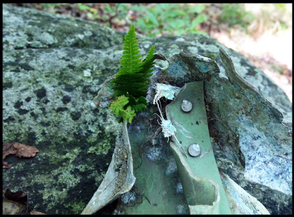
Remains of Northwest Airlines flight 6231, scattered in the forest in Harriman State Park, south of Lake Welch, between the Old Turnpike and the Long Path.
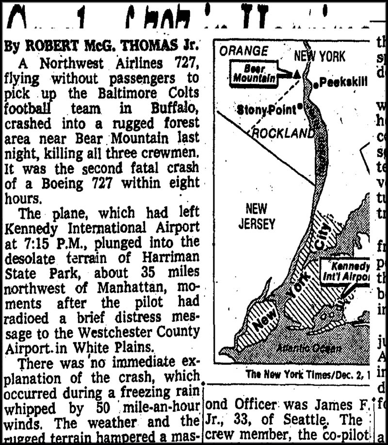
Some time ago I wrote about looking for a plane that went down in Harriman State Park in 1974. It was Northwest Airlines flight 6231 from New York, chartered by the Baltimore Colts. The plane, with three crew members, was heading to Buffalo, New York, to pick up the team, when it stalled over Harriman. It plunged into the woods one icy night in December.
I’d read the FAA report of the crash, and the co ordinates were given in error. Which led to me stumbling around in a swamp for a little while this summer.
If the co-ordinates had been correct, however, I would have found the wreck sooner. Yesterday, I found it by looking at a historic aerial photo from 1975, and then going to the place. I biked in on the Turnpike, then walked to coordinates N 41° 12.903 W 074° 05.335
The plane’s remains are located in a sunny, ferny glen between the Long Path and the Old Turnpike, south of Lake Welch.
You can see lots of debris there. It’s scattered under the ferns, lots of it. Dusky aqua-green metal, old rivets, twisted stuff that’s unidentifiable to those of us who don’t know much about airplanes.
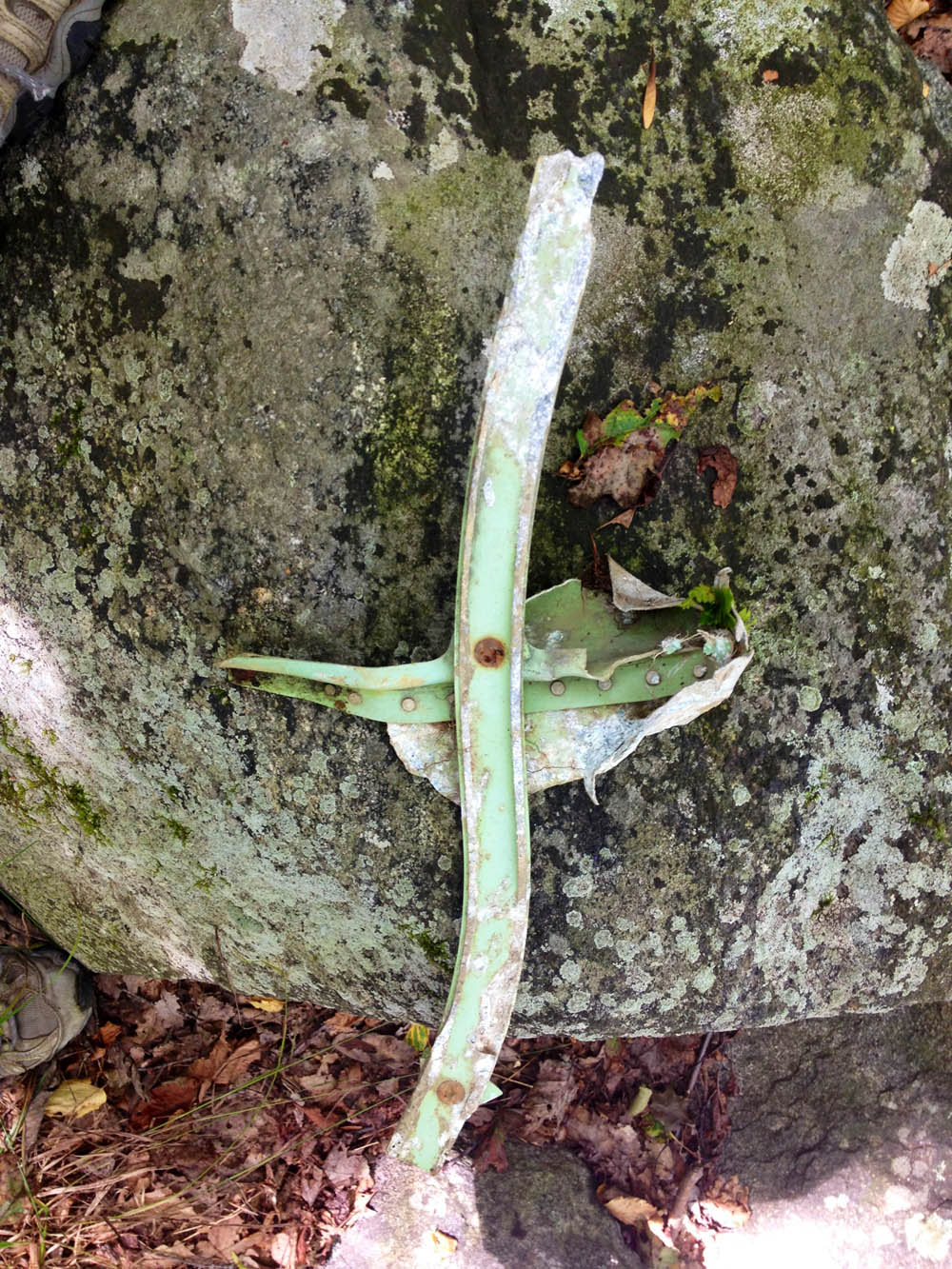
I found a piece, picked it up, and decided I didn’t want to be there anymore, and headed back up to the Old Turnpike. The piece of the airplane I found first was shaped like a little cross. Walking up to the path, I thought, it’s a shame there isn’t a memorial there, in the woods. I left the cross at the edge of the trail, propped up on a rock.


I was on the long path today just east of the Big Rock when I met a group of four people who told me about the plan crash. They said they were going to try to find it. I am surprise how small the debris you saw was. I run along the long path often and will try to find it. Thank you for not taking anything from the site.
She did take something from the site, Gary. She said “I found a piece, picked it up…” and then “I left the cross at the edge of the trail, propped up on a rock.” Later seekers might now find something where it wasn’t originally. I’m sure her actions were not ill-intentioned, but they are disappointing.
All true — thanks for the comment. I’ve thought about this a lot since then. Sometimes you figure things out after you’ve already acted.
Around Thanksgiving I hiked up the Fishkill Ridge on Beacon Mountain, and on the way down, a little ways off the trail, I saw a small pile of twisted metal and a framed newspaper article nailed to a tree. It marked the rough spot where war hero Dixie Kiefer’s plane crashed, carrying five other Navy men on November 12, 1945. It looks like people who find bits of the plane leave them in one place. There is a sort of memorial there, unlike the hillside at Harriman.
I mention this not because it strikes me as a better way to remember something that happened on a spot, but just a different way.
Suzy:
I went to the coordinates you supplied and could not see ANYTHING of a plane wreak. Could I have gone to the wrong place. I put it in my GSP on my phone. Please email be back. I am organizing a run on the 16th and wanted to take about 3 people to the site. I can supply you photos if you like
Gary: I’m so sorry. The coordinates were wrong. They are: N 41° 12.903 W 074° 05.335. I’ve changed this in my post. Have a great run!
There is another crash site up on Fishkill Ridge; it happened in the 40s. But on that spot, they’ve posted a memorial, and there is still debris from the crash. I think it would be nice if the Harriman spot was memorialized.
It’s amazing how much metal is still up there, after all these years.
I grew up about 3 miles from the crash site and walked to it the next morning
I remember the point of impact was almost strait down only broke off a few trees
I thought I would never hear about that again.
I have lived in Texas since moving from there 32years ago
Small world. Great memories
Thanks
Thanks for the coordinates! Went yesterday and found the site. Many small pieces still exist, though you may have to move around some leaves to find them. The best find for me was an actual AC piece from the plane (the knob you twist above your seat to turn the AC on). It was very surreal. I have pics of anyone wants to see let me know. Of course we did not remove anything from the site. Happy hiking 🙂
I went there last year, but did not have the correct coordinate, but I found a alien spaceship instead (not really, but the true is boring, just looked around and could not see anything) I hope to go back with the correct coordinate at some point.
Suzy do you have the coordinates for the crash on fishkill ridge???
I hope these are correct. I took a couple pictures of the sign posted at the Fishkill Ridge crash site — there’s a preserved newspaper article on a tree there — and the pictures are geotagged with these coordinates: 41.50274, -73.92491 (or, 41.50274 N, 73.92491 W). There is an unmarked trail that runs down the ridge from Bald Hill to the white-blazed trail near the Sunnyside Road parking area in Beacon Hills. If you’re heading downhill on that unmarked trail, the sign and site are off the trail to the left.
Thank You for your help Tony
Finally going to go back today to find this site, will let you know
I’m looking at a trail map right now and the Long Path and Old Turnpike parallel each other for quite a distance in this area. Could you lend any further details that might help in finding the location? For starters, is it east or west of where the SBM crosses?
Thanks…
Hi Brad. It’s between the Long Path and the Old Turnpike, west of where the Suffern-Bear Mountain trail crosses. If you look at the map, there’s a road that comes from the northeast end of Breakneck Pond. This road joins the Old Turnpike. At that point, if you head east on the Old Turnpike (and it becomes unpaved at this point) you’ll get to the site of the crash in just a few hundred feet. Or so. It’s down a slope on the north (left) side. There is a gully of ferns there.
^^^ Perfect. Thanks Suzy.
Brad:
I will send some photo’s to Suzy and maybe she can publish, I now consider myself the expert in finding the plane wreck since I tried to get there 4 times and only on the last did I find it. The first time, the wrong coordinates were posted. The second time was during the Irishman’s run were we just did not have enough time. The third time I was tracking my GPS to get there, then it just stopped working. When I look at the map later I was 150 yards away. Finally I make it there last weekend. I wish I could should you photos on this website to help you, but I will send the photo’s to Suzy. Bottom line there is a stretch of trees that have been knocked out years ago, but never grown back. My friend Bill Rowland guesses that the fire after the crash made such strong ground cover that only bushed could grow back. I don’t really know, but I will send photos to Suzy.
Found it! Not much to see, mind you. I imagine the site has been picked over and obviously grown over (but as indicated above, no trees have grown in, just ground cover mostly). Clearly the plane must have been on a steep plunge. The crash site is relatively small.
I recall the night of the crash and have been to the site many times. Your comments about the site not being identified, made me think that thousands of hikers walk thru the site every year oblivious to the fact that a large commercial plane with crew on board crashed there. I spoke to the PIP Conmmisioner who has no objections to an appropriate marker being placed at the site. I obtained pricing for a historical marker that would be permanently installed. Depending on the size and number of letters, the prices range to about $1200. I approached the PIP Historical Society and they are willing to donate half of the costs. Any ideas on where we can find a donor (s) for another $500-$600? I would then ask the PIP staff for assistance getting the site ready, etc. If we do not act, this piece of history will fade into the past in another 40 years, there will be no memory of the tragedy. Thanks. I can be reached at wreng@co.rockland.ny.us or 845 590 8708.
Gordon, thank you for the comment. Good news all around. The big stumbling block was getting permission, but now that you’ve done that, a fund raiser could bring in the rest quickly. I’ll send you an email today.
I also thought: Baltimore Ravens? Indianapolis Colts?
The Baltimore Colts moved to Indy in 1984. The Cleveland Brown moved to Baltimore in 1996, but changed their name (under league pressure) to the Baltimore Ravens so that the Browns could continue (under new ownership) in Cleveland.
Interesting news on the marker at the crash site. My concern would be two things…
1) Someone defacing or stealing the marker
2) With the site clearly identified, I imagine every last bit of the plane would be searched for and removed.
Suzy:
What has happened regarding the monument. John Lagorio was the United Captain and my first cousin’s husband.. If you are looking for assistance in raising the funds for an appropriate monument, please contact me.
Ted Hoepner
Ted, email me gary@reachoutcom.com
With the help of Gordon and my curiosity to find it I did find site one summer day last year I walked the path off of St. John’s in the Wilderness finally found it there were no plaque you could easily overlook site but it’s been 40 plus years so
Gordon Wren, Director of the Rockland County Fire and Emergency Services, Gary Scarano and Bill Rowland will be on 1300 AM radio show at 11:15 to speak about the 1974 Baltimore Colt Plane crash in Harriman State Park. Please tune in.
Suzy, please join us!!!
Gary and Bill, both RRR members and trail runners, found the crash site this year while running on the Long Path. and thought about putting up a memorial. When we saw Gordon’s desire to do the same and want to join forces with him.
Please post this on your respective sites as you can. It would be a great aid station break for a run 🙂
http://www.lohud.com/story/news/local/rockland/2014/12/24/rockland-remembers-year-old-plane-crash/20856647/
Tomorrow is the radio show, Feb 13th!!
Gorden Wren has secured funding for the Northwest Airlines flight 6231 memorial. We are in the process of contacting family members of the crew that passed away for approved wording on the memorial. We are in touch with the window of Captain John B, lagorio, but have not been able to contact family members of First Officer Walter A. Zadra, and Second Officer Jams F. Cox. If anyone is in contact with these people please have them email me so we can get approval from the families for the wording on the memorial
I am the daughter of Walter Zadra. My aunt has told me about the memorial, but I don’t have any information about it. Could someone let me know?
Regarding the memorial please call me 914 907 2785
http://www.myharrihttp://www.lohud.com/story/news/local/rockland/stony-point/2015/11/02/4-decades-later-memorial-stony-point-plane-crash/74864974/man.com/?s=crash
Please read this story about the memorial, over 40 years overdue, that is taking place this Saturday, Nov. 7th with a Church Service at St. Johns in the Wilderness church followed by the dedication at the crash site about 1 mile away by trail, about 2.5 by car.
Last Spring,2016 my husband and I were doing a hike in that area which I have done numerous times, always feeling like something was amiss in that area, ever since I read about that crash in my Harriman book. It was one of my last hikes as I suffered a severe back injury shortly after that. We came across the monument that day and I was overjoyed to see the monument. We also just happened to speak to a man that was in the area at the time of the accident and gave us more info that made it even more real. I am so glad that other people feel the same way I feel and I appreciate all the hard work and the eagle -eyed people that found so many remnants of the plane. The victims of that day will never be forgotten.
After all these years I can still vividly remember the aqua green and cream livery on the fuselage parts. I visited the crash site shortly after it happened. My friend and I hiked in from St. John’s in the Wildneress where is father was the minister. I recall seeing boots and scattered wreckage parts of which I took quite a few. They made their home in my parents garage for years. Since the site was very fresh, you could clearly trace the plane’s approach path by the way the tree trunks were snapped. I still think about the wreck to this day.
I’m a retired NWA Crew Chief. My crew had dispatched the B727 from JFK at about 1030 pm. The flight was supposed to leave at 7:15pm but it was delayed departing due to weather. The next day I drove to the crash site. I was asked to photograph the wreckage. Very sad occurance.
I’ve walked and even XC skied past the memorial since this thread started nearly 10 years ago. Very few photos seem to exist of the crash site from the 70’s. It would be interesting to compare to today. I suspect, not substantially different owing to the fact that trees haven’t really gown back in; I suspect due to all the fuel which did not burn (there was no fire).